Ётамс сёрматфть няфтьфонц потмос (содержаниянцты)

Няйф:Stryi and Upper Dneistr Rivers.PNG

Лопать лангса уликссь аш кода нолдамс тевс лия кяльхнень коряс.
Википедиесь лопаста

Васень файла (631 × 648 пикселхть, файлть сталомоц (мароц): 63 КБ, MIME типоц: image/png)

Тя файлась на Викискладе-ста ули кода нолдамс иля теварьсефкснень эса. Колганза тяштьфсь файлать азондома лопастонза няфтьф ала.

Лихтема

Сёрмадома
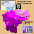
English: This is a map showing the Upper Dniestr River Basin, including its main tributary, the Stryi River, in the southwestern half of the Lviv Oblast in western Ukraine. It also shows the average annual precipitation by millimeters and inches for the region, and places the administrative centers of each of the raions in this area on the map. It includes and inset indicating where this is in relation to the rest of Ukraine, and provides the names of the closest villages to the Stryi River's head and mouth. I created this map, using Microsoft Paint, version 7.0, and borrowing data from Google Earth, and the 21st European Regional Conference 2005 - 15-19 May 2005 - Frankfurt (Oder) and Slubice - Germany and Poland report on "Floods Modeling in the Upper Dnister River Valley", by Ivan Kovalchuk, Andriy Mykhnovych, Volker Ehlert, Jörg Steidl, in conjunction with the Leibniz Centre for Agricultural Landscape Research (ZALF), Germany, and held at the Ivan Franko National University of L’viv, Ukraine, page4. URL: http://www.zalf.de/icid/ICID_ERC2005/HTML/ERC2005PDF/Topic_2/Kovalchuk.pdf
Пинге 10 Уфайковста 2010 (дата первоначальной загрузки файла на вики)
Лисьмапря Transferred from en.wikipedia to Commons by SreeBot.
Арьсиня Saukkomies из Англань кяль Википедие

Кемокстама

Public domain Автор этого произведения, Saukkomies из Англань кяль Википедие, передаёт его в общественное достояние. Это разрешение действует по всему миру.
В некоторых странах это не может быть возможно юридически, в таком случае:
Saukkomies предоставляет любому право использовать данное произведение в любых целях, без каких-либо условий, если только такие условия не требуются по закону.

Исходный журнал загрузок

The original description page was here. All following user names refer to en.wikipedia.

Upload date | User | Bytes | Dimensions | Comment

  • 2010-02-10 01:12 (UTC) | Saukkomies | 64995 (bytes) | 631×648 | I created this map, using Microsoft Paint, version 7.0, and borrowing data from Google Earth, and the 21st European Regional Conference 2005 - 15-19 May 2005 - Frankfurt (Oder) and Slubice - Germany and Poland report on "Floods Modeling in the Upper Dnist

Краткие подписи

Добавьте однострочное описание того, что собой представляет этот файл

Элементы, изображённые на этом файле

изображённый объект Рузонь кяль

Файлать пингелувксоц

Люпштак шить/пингть лангс ся пингть файлать няеманди.

Ши/ПингеАнцяйняОцюлмацСувайМяльполаткс
тяниень17:36, 18 Козяковста 2011Анцяй 17:36, 18 Козяковста 2011-ть эста631 × 648 (63 КБ)SreeBot(Original text) : I created this map, using Microsoft Paint, version 7.0, and borrowing data from Google Earth, and the 21st European Regional Conference 2005 - 15-19 May 2005 - Frankfurt (Oder) and Slubice - Germany and Poland report on "Floods Modeling

Те файлать мархта сюлмаф вага тяфтама лопа:

Файлань эрьва мезень тевс нолдама

Тя файлась тевс нолдави стама викитнень эса: